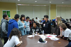
 About 100 students from Hyattsville Middle School participated in a simulation hosted by START that examined the geographical and geopolitical background of the conflict in Mali. The students were at the University of Maryland as part of International GIS Day, hosted on campus by the Department of Geographical Sciences in the College of Behavioral and Social Sciences.
START commissioned teams of the middle school students to find a peaceful solution in Mali, where reignited tensions over land and cultural rights earlier this year have resulted in Mali spiraling into a complicated civil conflict. Students played the roles of representatives for Algeria, Niger, Cote D'Ivoire, France and Burkina Faso and the Interim Government of Mali. 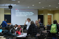
The middle schoolers learned how the situation in Mali threatens not just the stability of the country itself, but the prosperity, security and stability of the whole region. In their simulation activity, they experienced the difficulties that can occur during an international negotiation, where many of the actors may have conflicting aims and motives.
START participated in the GIS Day information fair and discussed the GIS and mapping work currently underway at the Consortium, including the ongoing geocoding of information in the Global Terrorism Database. START is actively seeking to expand its GIS capabilities.